

أبحاث مصرية بدأت قبل أكثر من 30 عامًا في الصحراء الشرقية وأسوان، رصدت انتقال الذهب إلى النباتات.. فهل تتحول الدراسات المتفرقة إلى برنامج وطني يجمع الاستكشاف الحيوي وإدارة مخلفات التعدين والغابات؟
قبل أربع سنوات من نشر تجربة «حصاد الذهب بالنباتات» في مجلة Nature عام 1998، كان باحثون في جنوب شرق الصحراء الشرقية المصرية يطرحون سؤالًا قريبًا، وإن كان له هدف مختلف: هل تستطيع النباتات الصحراوية أن تكشف ما تخفيه الأرض من معادن؟
وفي نوفمبر 1994، نشرت مجلة Journal of Arid Environments دراسة للباحثين M.A. Badri وIrina Springuel بعنوان Biogeochemical prospecting in the South-Eastern Desert of Egypt، حللت تسعة عناصر معدنية في 20 نوعًا من نباتات الصحراء، بهدف تحديد قدرة النباتات على العمل كمؤشرات في الاستكشاف المعدني.
أظهرت النتائج أن النباتات لا تمتص العناصر بالطريقة نفسها؛ فلكل نوع قدرته الانتقائية، ومع ذلك برزت ثلاثة نباتات بصفة خاصة باعتبارها مؤشرات محتملة للتمعدن: Maerua crassifolia وZilla spinosa وBalanites aegyptiaca.
لم تكن الدراسة لاأساس مخصصة لاستخراج الذهب بالنبات، ولا مخصصة للذهب وحده، لكنها تضع مصر مبكرًا داخل أحد الفروع التي أصبح لها اليوم وزن متزايد في الاستكشاف العالمي: Biogeochemical Prospecting – الاستكشاف البيوجيوكيميائي.
واللافت أن Zilla spinosa، التي ظهرت في ذلك البحث قبل أكثر من ثلاثة عقود، ستعود بعد 30 عامًا لتصبح أحد النباتين اللذين اختبرهما بحث مصري جديد خصيصًا للاستكشاف عن الذهب.
منشور ذو صلة: حدائق الذهب
أسوان 1995.. الذهب يظهر في النبات
بعد عام واحد، قدم د. محمد نجيب راشد دراسة أخرى في Journal of Arid Environments، حلل فيها العناصر النزرة داخل سبعة نباتات تنمو في أسوان.
هذه المرة كان الذهب Au نفسه ضمن العناصر المقاسة إلى جانب الفضة والكادميوم والكوبالت والنحاس والحديد والمنجنيز والنيكل والرصاص والزنك وغيرها.
لم يكن الهدف من الدراسة البحث عن منجم ذهب، وإنما فهم قدرة نباتات المناطق الحارة على امتصاص العناصر من التربة وتأثير ذلك غذائيًا وبيئيًا. لكنها قدمت دليلًا مصريًا مبكرًا على انتقال الذهب إلى أنسجة النباتات في بيئة أسوان.
وبعد نحو ثلاثة عقود، عاد بحث مصري أحدث إلى هذه النتائج، مشيرًا إلى أن Cyamopsis tetragonolobus في شرق أسوان سجل امتصاصًا للذهب وصل إلى نحو 4.6 ميكروجرام/كجم. كما أشار إلى نتائج مصرية أخرى في جبل قطار بالصحراء الشرقية، سجلت الذهب داخل أنواع محلية بينها Zygophyllum coccineum وZilla spinosa وFagonia boveana وAerva javanica وMoringa peregrina. كانت هناك، إذن، إشارات متناثرة تقول الشيء نفسه: النبات المصري يحمل معلومات عن الأرض التي ينمو فوقها. لكن هذه المعلومات لم تتحول إلى خريطة.
وادي العلاقي.. نبات يحمل ذاكرة منجم عمرها قرن
في عام 2010، انتقل البحث المصري خطوة أكثر قربًا من قضية الذهب ومخلفات التعدين، درس الدكتور محمد نجيب راشد الاستاذ بجامعة أسوان، مخلفات منجم قديم في وادي العلاقي جنوب شرق أسوان، إلى جانب التربة المحيطة والنباتات البرية التي استعمرت المنطقة، ونشر النتائج في Journal of Hazardous Materials.
الموقع نفسه كان مختبرًا طبيعيًا نادرًا، فقد استُخدم المنجم قديمًا بواسطة المصريين ثم شركات إنجليزية، وكان الذهب يستخلص باستخدام المواد المحتوية على الزئبق، حيث يطحن الخام ثم يمر فوق ألواح نحاسية مغطاة بالزئبق لالتقاط الذهب، بينما كانت المخلفات تلقى بالقرب من موقع المعالجة. وظلت تلك المخلفات لعقود تتعرض للرياح والتجوية والانتشار في البيئة المحيطة.
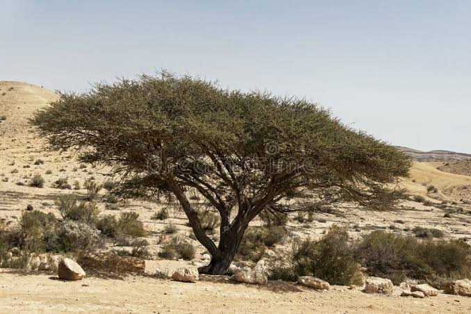
حللت الدراسة مخلفات التعدين والتربة ونباتي Acacia raddiana وAerva javanica، ولم تبحث عن الذهب وحده، بل تتبعت معادن وعناصر أخرى مثل: Hg وCd وPb وAs إلى جانب Cr وAg وNi وAu وMo وZn وMn وCu.
وأظهرت النتائج انتقال التلوث من المخلفات إلى التربة والغطاء النباتي، وانخفاض تراكيز عدد من العناصر، بينها الذهب، كلما ابتعدت العينات عن أكوام المخلفات، قبل أن تتداخل لاحقًا تأثيرات الصخور المحيطة. كما أظهر السنط قدرة أعلى من Aerva javanica على تراكم الزرنيخ والكادميوم والرصاص.
وكانت خاتمة الدراسة حاسمة: التربة والنباتات القريبة من المخلفات شديدة التلوث، ولا ينبغي استخدامها للزراعة أو الرعي.
وهنا يقدم العلاقي درسًا بالغ الأهمية لأي حديث عن إمكانية زراعة حدائق الذهب على أنقاض المناجم المنتهية. لتثبت أن النبات قد يستطيع أن يساعد في استعادة الأرض بالفعل، لكنه يستطيع أيضًا أن ينقل ما في الأرض إلى السلسلة الحيوية.
ولهذا لا يجوز النظر إلى التشجير فوق مخلفات الذهب باعتباره مسألة زراعة فقط، فاختيار النوع النباتي، وتحليل أجزائه، وتتبع الزئبق والزرنيخ والرصاص والكادميوم يجب أن يكون جزءًا من التصميم منذ البداية.
العلاقي نفسه يقدم نصف الخريطة
في العام نفسه، نشرت دراسة جيولوجية مستقلة عن الاستكشاف الجيوكيميائي للذهب في Nile Valley Block A بوادي العلاقي.
حللت الدراسة رواسب المجاري المائية وحددت الشذوذات الجيوكيميائية للذهب، وخلصت إلى أن الفضة والكادميوم والسيلينيوم والزنك والتيلوريوم يمكن أن تعمل كعناصر دالة Pathfinders للذهب في الجزء الخشن من الرواسب بالمنطقة.
وتصبح أهمية هذه النتيجة أكبر إذا وضعت بجوار الدراسات النباتية، فبدلا من تحليل النبات بحثًا عن Au وحده، يمكن بناء المسح المصري على بصمة متعددة العناصر: ذهب داخل النبات، وعناصر دالة مصاحبة، وتربة أسفل النبات، ثم مقارنة النمط كله بالجيولوجيا والرواسب والجيوفيزياء. وهو ما يجعل الاستكشاف البيوجيوكيميائي أداة مكملة للاستكشاف التقليدي، وليس بديلًا عنه.
المسّيكات.. النبات يعود للبحث عن الذهب
في 2024 جاءت أقرب دراسة مصرية حتى الآن إلى السؤال الذي يطرحه هذا التحقيق مباشرة.
اختار د. أسامة عبد المنعم عبيان، الباحث بهيئة المواد النووية، نباتي Lotus hebranicus وZilla spinosa من وادي المسّيكات بالصحراء الشرقية، ودرس علاقتهما بالتربة الموجودة تحتهما بهدف استخدام النباتات البرية في الاستكشاف البيوجيوكيميائي للذهب، ولم يكن الاختيار عشوائيًا، فقد وقع الاختيار على النباتين المعمرين والمنتشرين في منطقة الدراسة، أي أنهما يظلان في الموقع فترة أطول ويعكسان الظروف البيئية المحيطة بهما بصورة أفضل من نباتات موسمية قصيرة العمر.
وجُمعت عينات النبات مع عينات من أول 30 سنتيمترًا من التربة، ثم خضعت لتحاليل متعددة العناصر باستخدام ICP-AES وICP-MS، مع تحليل الذهب والعناصر المصاحبة له.
كانت التربة الموجودة أسفل النباتات تحتوي على 91 إلى 160 ميكروجرامًا من الذهب لكل كيلوجرام، بمتوسط 106 ميكروجرامات/كجم، وهي قيم اعتبرتها الدراسة مؤشرًا على إثراء بالذهب واحتمال وجود تمعدن في الصخور القريبة.
لكن المفاجأة الأهم ظهرت داخل النبات نفسه، حيث بلغ متوسط الذهب في Lotus نحو 10.7 ميكروجرام/كجم، ووصل أعلى تركيز إلى 11.5 ميكروجرام/كجم، مقابل متوسط يقارب 1.3 ميكروجرام/كجم في Zilla. كما ظهر ارتباط واضح بين تركيز الذهب في النبات وتركيزه في التربة الموجودة أسفله.
ووجد البحث أيضًا ارتباطات بين الذهب وبعض العناصر الدالة عليه، خاصة الفضة والأنتيمون، وخلص إلى أن ارتفاع الذهب في النباتات والتربة، إلى جانب العلاقة مع العناصر المصاحبة، يمكن أن يكون مؤشرًا على تمعدن ذهبي في الصخور المجاورة.
ولم تتمثل النتيجة المهمة لهذه الدراسة في إثبات أن Lotus hebranicus أصبح “نباتًا لتعدين الذهب”. فالدراسة لم تثبت ذلك ولم تختبر جدواه الاقتصادية من الأساس، لكنها أثبتت شيئاً أكثر قابلية للتطبيق حاليًا في مصر: نبات بري يعيش بالفعل في الصحراء الشرقية استطاع أن يحمل في أنسجته إشارة قابلة للقياس ترتبط بالذهب الموجود في التربة تحته.
أي أن النبات أصبح مؤهلا لاعتماده كمستشعر حيوي للبيئة في مصر، كما حدث عالميًا مع الأوكالبتوس الأسترالي.
من النبات إلى الخام.. حلقة مصرية أخرى في المسّيكات
وادي المسّيكات يقدم حلقة بحثية أخرى لا تتعلق بالنبات مباشرة، لكنها مهمة إذا انتقل البحث مستقبلًا من الاستكشاف إلى الاسترداد.
ففي 2020 نُشرت دراسة عن استخلاص الذهب باستخدام الثيويوريا من مخلفات خامات اليورانيوم بجبل المسّيكات، بما يعني أن الموقع نفسه شهد بحثًا مصريًا في جانب آخر من السلسلة: معالجة مخلفات تحتوي على ذهب ومحاولة استرداده بطرق كيميائية. وتشير إليها دراسة عبيان 2024 ضمن الأدبيات المرتبطة بالمنطقة.
وهنا تبدأ القطع المتفرقة في الاقتراب من بعضها وسرم صورة أوضح:
لدينا جيولوجيا وتمعدن. ولدينا مخلفات يمكن إعادة تقييمها. ولدينا نباتات محلية قادرة على التقاط الإشارة الجيوكيميائية. ولدينا خبرة بحثية مصرية في المعالجة المعدنية والحيوية. فلماذا لا نضع هذه القطع بعد داخل تجربة واحدة؟.
مصر.. لماذا تنتظر إغلاق المناجم؟
تختلف نقطة البداية المصرية عن كثير من النماذج العالمية التي بدأت بعد إغلاق مناجم كبيرة وظهور مشكلة استصلاح أراضيها.
فمصر في 2026 تدخل مرحلة توسع في تعدين الذهب؛ فالسكري لا يزال المنتج التجاري الرئيسي، بينما تتقدم مشروعات واستثمارات جديدة، وتستهدف الدولة توسيع الإنتاج والاستكشاف.
وهذا يمنحها فرصة مختلفة: أن تصمم إدارة مخلفات التعدين والعمر التالي للأرض منذ بداية الصناعة، لا بعد انتهاء المنجم. وقد أنتجت عمليات التعدين الحرفي- الأهلي – بالفعل أطنانا من المخلفات الملقاة في الجبل حول مناطق الطواحين،
فبدل أن ننتظر عشرات السنوات ثم نسأل كيف نعالج جبال المخلفات، يمكن منذ بداية التشغيل تحديد تركيبها المعدني، وكمية الذهب المتبقية فيها، والعناصر الخطرة المصاحبة، وإمكانية إعادة معالجتها، ثم تصميم برامج الاستصلاح النباتي بالتوازي مع حياة المنجم.
ولا يعني ذلك زراعة أشجار فوق مخلفات نشطة دون معالجة، وإنما ترتيب العملية علميًا: استرداد ما يمكن استرداده اقتصاديًا، ثم خفض المخاطر الكيميائية، ثم اختبار النباتات والميكروبات المناسبة، ومراقبة التربة والمياه والكتلة الحيوية على المدى الطويل. بهذا المعنى، يصبح «منجم ما بعد المنجم» جزءًا من تصميم المنجم الأول نفسه.
هل تستطيع الأشجار أن تضيف طبقة جديدة إلى خريطة الذهب المصرية؟
هناك مسار آخر قد يكون أسرع في الاختبار وأقل تكلفة ولا يغني مرحلة من المراحل التي سبقت الإشارة إليها، فاستخدام النباتات في الاستكشاف ليس بالفكرة الجديدة، بل هي موجودة بالفعل.
فخلال 2026 تبدأ مصر مشروعًا للمسح الجوي الجيوفيزيقي الشامل للثروات المعدنية، هو الأول من نوعه على هذا النطاق منذ 42 عامًا، بالتعاون بين هيئة الثروة المعدنية والصناعات التعدينية وشركة Xcalibur وهيئة المواد النووية وDrone Tech، بهدف إنتاج قاعدة بيانات حديثة وعالية الدقة للموارد المعدنية.
وفي الوقت نفسه تمتلك هيئة الثروة المعدنية خبرة مؤسسية في الاستكشاف الجيولوجي والجيوكيميائي للصخور والتربة ورواسب الأودية وربط الشذوذات الجيوكيميائية بالتمعدن الحقيقي.
فلماذا لا تضاف إلى هذه الخريطة طبقة حيوية أخرى؟
ليس باستبدال الطائرات أو الأقمار الصناعية أو أخذ العينات الجيولوجية بالأشجار، وإنما باختيار مناطق محددة ظهرت فيها إشارات واعدة، ثم أخذ عينات معيارية من الأنواع النباتية الموجودة فوقها ومقارنتها بمناطق التحكم.
وفي الصحراء الشرقية لدينا بالفعل قائمة أولية صنعتها الأبحاث المصرية نفسها: Lotus hebranicus، وZilla spinosa، وAerva javanica، وAcacia، وZygophyllum coccineum، وFagonia boveana، وMoringa peregrina وغيرها. ليتم توسيع نطاق البحث بطول منطقة وادي النيل، وبدلا من الاكتفاء بالمسح الجوي للصحاري المصرية، يتم البحث عن الذهب والمتعدنات الغرينية في مسار النهر من بحيرة ناصر حتى مصب فرعي النيل، ليصبح البحث ليس عن أى منطقة تحتوي على الذهب” فقط.. بل عن أكثر موقع ونوع نبات يعطي أكثر إشارة استقرارًا وقابلية للتكرار عن الذهب الموجود تحته.
بحيرة ناصر وتوشكى.. امتداد وادي العلاقي
وتكتسب منطقة جنوب أسوان أهمية خاصة لأن وادي العلاقي نفسه يمتد على الجانب الشرقي من بحيرة ناصر، بينما سجلت الدراسات النباتية والبيئية للمنطقة تنوعًا واسعًا للغطاء النباتي وتأثره بالتغيرات التي أحدثتها البحيرة.
وهنا يمكن طرح سؤال أو فرضية تستحق البحث: هل تستطيع النباتات الموجودة حول نظم التصريف والرواسب في جنوب مصر تسجيل إشارات للعناصر القادمة من مناطق التمعدن؟
وتصبح توشكى مهمة لسبب آخر: مركز بحوث الصحراء لديه محطة بحثية هناك بالفعل، إلى جانب محطة شلاتين ومختبر مركزي لتحليل التربة والمياه والنبات، وبنك لجينات النباتات الصحراوية ونظم معلومات جغرافية. أي أن جزءًا من البنية البحثية اللازمة للمشروع موجود بالفعل بالقرب من البيئة التي نريد دراستها.
الدلتا.. “أرض زراعية من ذهب”.
في 2026، نشرت The Egyptian Journal of Remote Sensing and Space Sciences دراسة عن إمكانات التمعدن الذهبي في منطقة الدلتا الجديدة.
جمعت الدراسة الاستشعار عن بعد والتحليل الجيوكيميائي، وأكدت تحاليل Fire Assay لعشر عينات مختارة من الحجر الرملي بتكوين المغرة Moghara Formation تراكيز ذهب بين 3 و8 أجزاء في المليون، بمتوسط 5.8 جزء في المليون.
والدراسة لا تعني بالضرورة أن التربة الزراعية التقليدية للدلتا تحتوي على 3–8 جرامات ذهب في الطن، ولا أنها أصبحت هدفًا للتعدين. لكنها مجرد رصد لتكوين جيولوجي محدد في منطقة الدلتا الجديدة.
وقيمتها بالنسبة لهذا الملف أنها توسع السؤال الجغرافي: إذا ظهرت تمعدنات أو شذوذات جيولوجية في مناطق تغطيها رواسب أو زراعات، فهل تستطيع النباتات أن تضيف أداة آمنة للاستكشاف؟
حيث تعد أراضي منطقة الدلتا أهم الأراضي المنتجة للغذاء في مصر، لذلك يصبح أمر استخدام المواد الكيميائية مثل السيانيد والثيوسيانات ومواد تحريك المعادن في التربة أمرا غير مطروح من الأساس.
بدل “حدائق ذهب”.. تجربة مصرية بثلاثة مسارات
المعرفة الموجودة في مصر تسمح الآن بالانتقال من الدراسات المنفردة إلى برنامج تجريبي متعدد التخصصات.
المسار الأول هو الاستكشاف الحيوي: توحيد طريقة أخذ عينات النبات والتربة في مناطق ذهب معروفة ومناطق تحكم، ثم اختبار الأنواع المحلية وتحديد أكثرها دقة في عكس الشذوذات الجيولوجية.
والثاني هو مخلفات التعدين: اختيار موقع تاريخي أو مخلفات معروفة التركيب، ودراسة انتقال الذهب والزئبق والزرنيخ والعناصر الثقيلة بين المخلفات والتربة والمياه والنبات، ثم اختبار نباتات غير غذائية لإعادة التأهيل.
والثالث، وهو الأكثر تجريبية، غابة حيوية صغيرة محكومة: أشجار مختارة فوق وسط معروف التركيب، مع قياس سنوي للذهب والعناصر المصاحبة في الجذور والخشب والأغصان والأوراق والأوراق المتساقطة، ودراسة ما إذا كان التقليم والحصاد الجزئي للكتلة الحيوية يستطيعان إخراج جزء من المعادن من الموقع بمرور الوقت.
ولا ينبغي أن يبدأ المسار الثالث بهدف قياس كميات الذهب المستخرجة، ولكن برصد حركة الذهب أثناء انتقاله من الأرض إلى النبات والعوامل المؤثرة فيه، ثم تأتي الجدوى الاقتصادية منه لاحقاً.. وربما لا تكون الجدوى في استخلاص المزيد من الخام، بل في اعادة استصلاح واستغلال الأرض المنهكة بعد عمليات التعدين والملوثات التي تعرضت لها، وتحويلها إلي مشروع تنموي مستدام يمكن بعد سنوات أن يقدم منتجاً خشبياً صالحا للاستخدام، بعد سنوات من امتصاص ثاني أكسيد الكربون وإطلاق الأكسجين.
مصر لديها بالفعل تجربة في «الغابة والمياه والمعادن»
لا يزال هناك عنصرا من عناصر التجربة غائبا، وهو المياه الذي قد يبدو عقبة أمام التشجير في مناطق التعدين الجافة، لا يبدأ من الصفر. إلا أن الأمر لا يعني استحالة التجربة، فمصر لديها غابات صحراوية تروى بمياه الصرف المعالجة، بينها السادات وسرابيوم، وأجريت دراسات مصرية طويلة المدى على الأوكالبتوس والكازورينا والسرو وأنواع أخرى لقياس النمو وانتقال العناصر والمعادن بين المياه والتربة وأنسجة الأشجار.
كما تؤكد منظمة FAO أن مصر من الدول التي طورت برامج لإعادة استخدام مياه الصرف المعالجة في الأحزمة والغابات الخشبية بالمناطق الجافة.
وهذا لا يثبت إمكانية ري “غابات الذهب مباشرة بمياه الصرف بشكل مباشر، لكنه يعني أن لدينا خبرة مصرية في النصف الآخر من المعادلة: كيف نزرع أشجارًا غير غذائية في الصحراء بمصدر مائي غير تقليدي، وكيف نراقب انتقال المعادن إلى أنسجتها، وكيف نحولها فيما بعد إلى رئة تضح الأكسجين في الهواء وكيف يتم القضاء عبر السنوات على الملوثات التي امتدت آثارها في تربة المناجم بعد استخلاص المعادن منها.
Egypt’s Living Gold Map: Can Plants Lead the Way to the Country’s Hidden Mineral Wealth?
Egyptian research dating back more than 30 years—from the Eastern Desert to Aswan—has documented the movement of gold into plants. Could these scattered studies now be brought together in a national programme combining biogeochemical exploration, mine-waste management and forestry?
Four years before an experiment on “harvesting gold with plants” was published in Nature in 1998, researchers working in Egypt’s southeastern desert were already asking a related question, albeit with a different objective: can desert plants reveal the minerals hidden beneath the ground?
In November 1994, M.A. Badri and Irina Springuel published a study in the Journal of Arid Environments titled “Biogeochemical Prospecting in the South-Eastern Desert of Egypt.” The researchers analysed nine mineral elements in 20 desert plant species to determine whether plants could serve as indicators in mineral exploration.
The results showed that plant species do not absorb elements in the same way; each has its own selective uptake capacity. Three species nevertheless stood out as potential indicators of mineralisation: Maerua crassifolia, Zilla spinosa and Balanites aegyptiaca.
The study was not designed to extract gold using plants, nor was it devoted exclusively to gold. Yet it placed Egypt at an early stage within a field that has since gained increasing importance in global exploration: biogeochemical prospecting.
Notably, Zilla spinosa, which appeared in that research more than three decades ago, would return 30 years later as one of two species tested in a new Egyptian study specifically concerned with gold exploration.
Aswan, 1995: Gold Appears in Plants
One year later, Dr Mohamed Naguib Rashed published another study in the Journal of Arid Environments, analysing trace elements in seven plant species growing in Aswan.
This time, gold (Au) itself was among the elements measured, alongside silver, cadmium, cobalt, copper, iron, manganese, nickel, lead, zinc and others.
The study was not intended to locate a gold mine. Its purpose was to understand how plants in hot regions absorb elements from the soil, as well as the nutritional and environmental implications. Nevertheless, it provided early Egyptian evidence that gold can move into plant tissue in the Aswan environment.
Nearly three decades later, a more recent Egyptian paper revisited those findings, reporting that Cyamopsis tetragonolobus in eastern Aswan had absorbed gold at a concentration of approximately 4.6 micrograms per kilogram. It also cited other Egyptian findings from Gabal Gattar in the Eastern Desert, where gold was detected in native species including Zygophyllum coccineum, Zilla spinosa, Fagonia boveana, Aerva javanica and Moringa peregrina.
The signals were therefore already present, although scattered: Egyptian plants contain information about the ground in which they grow. But that information has never been transformed into a map.
Wadi Allaqi: Plants Carry the Memory of a Century-Old Mine
In 2010, Egyptian research moved closer to the questions of gold and mining waste. Dr Mohamed Naguib Rashed of Aswan University studied the tailings of an old mine in Wadi Allaqi, southeast of Aswan, along with the surrounding soil and the wild plants that had colonised the site. The findings were published in the Journal of Hazardous Materials.
The site was a rare natural laboratory. It had been mined in the past by Egyptians and later by British companies. Gold was recovered using mercury-containing materials: the ore was crushed and passed over mercury-coated copper plates to capture the gold, while the resulting tailings were dumped near the processing site. For decades, those tailings remained exposed to wind, weathering and dispersal into the surrounding environment.
Can Plants Draw a Living Map of Gold in Egypt?
The study analysed mining tailings, soil, and the plants Acacia raddiana and Aerva javanica. It did not examine gold alone, but tracked several metals and elements, including Hg, Cd, Pb and As, as well as Cr, Ag, Ni, Au, Mo, Zn, Mn and Cu.
The findings showed that contamination had moved from the tailings into the soil and vegetation. Concentrations of several elements, including gold, declined as samples were collected farther from the waste piles, before the influence of the surrounding rocks began to overlap with the waste-related pattern. Acacia also showed a greater capacity than Aerva javanica to accumulate arsenic, cadmium and lead.
The study’s conclusion was unequivocal: soil and plants close to the tailings were heavily contaminated and should not be used for cultivation or grazing.
Wadi Allaqi therefore offers a critical lesson for any proposal to establish “gold gardens” on exhausted mine sites. Plants may indeed help restore degraded land, but they can also transfer what is present in the soil into the biological chain.
Revegetating gold tailings must therefore never be treated as a simple planting exercise. Selecting the appropriate species, analysing different plant tissues, and monitoring mercury, arsenic, lead and cadmium must be built into the project from the outset.
Wadi Allaqi Already Provides Half the Map
In the same year, an independent geological study was published on geochemical gold exploration in Nile Valley Block A in Wadi Allaqi.
The researchers analysed stream sediments, identified gold-related geochemical anomalies, and concluded that silver, cadmium, selenium, zinc and tellurium could serve as pathfinder elements for gold in the coarse sediment fraction of the area.
This conclusion becomes more valuable when considered alongside the plant studies. Rather than analysing plants for Au alone, an Egyptian survey could be built around a multi-element signature: gold in the plant, associated pathfinder elements, the soil beneath the plant, and a comparison of the entire pattern with geology, sediments and geophysical data. In that model, biogeochemical prospecting becomes a complementary tool—not a substitute for conventional exploration.
El-Missikat: Plants Return to the Search for Gold
In 2024, an Egyptian study came closer than any previous local research to the central question posed by this investigation.
Dr Osama Abd-Elmoniem Ebyan, a researcher at Egypt’s Nuclear Materials Authority, selected Lotus hebranicus and Zilla spinosa from Wadi El-Missikat in the Eastern Desert and studied their relationship with the soil beneath them, with the aim of using wild plants in biogeochemical gold exploration.
The selection was deliberate. Both species are perennial and widely distributed across the study area, meaning they remain at the site for longer periods and may reflect surrounding environmental conditions more reliably than short-lived seasonal plants.
Plant samples were collected together with samples from the upper 30 centimetres of soil. They then underwent multi-element analysis using ICP-AES and ICP-MS, including tests for gold and its associated elements.
The soil beneath the plants contained between 91 and 160 micrograms of gold per kilogram, with an average of 106 micrograms per kilogram. The researchers regarded these values as evidence of gold enrichment and a possible indication of mineralisation in nearby rocks.
The more striking finding, however, appeared inside the plants themselves. Average gold concentration in Lotus reached approximately 10.7 micrograms per kilogram, with a maximum of 11.5 micrograms per kilogram, compared with an average of around 1.3 micrograms per kilogram in Zilla. The study also identified a clear relationship between the concentration of gold in the plants and that in the soil beneath them.
Gold was additionally associated with several pathfinder elements, particularly silver and antimony. The researchers concluded that elevated gold levels in both plants and soil, together with their relationship with associated elements, could indicate gold mineralisation in neighbouring rocks.
The significance of the study does not lie in proving that Lotus hebranicus has become a “gold-mining plant.” It did not demonstrate that, nor did it test the economic feasibility of extracting gold from the plant. Instead, it established something more immediately applicable in Egypt: a wild species already growing in the Eastern Desert can carry a measurable biological signal linked to the gold in the soil beneath it.
The plant may therefore qualify as a candidate bioindicator for the Egyptian environment, much as eucalyptus has been used in Australia.
From Plant to Ore: Another Egyptian Link at El-Missikat
Wadi El-Missikat offers another strand of research that does not directly concern plants, but could become important if future work moves from exploration towards recovery.
In 2020, a study was published on the use of thiourea to recover gold from uranium-ore residues at Gabal El-Missikat. This means that the same site has hosted Egyptian research at another point in the value chain: processing gold-bearing residues and attempting to recover the metal chemically. The 2024 study by Ebian refers to this work among the literature associated with the area.
The separate pieces now begin to form a clearer picture. Egypt has the geology and mineralisation. It has tailings that can be reassessed. It has native plants capable of capturing geochemical signals. It also has Egyptian research expertise in mineral and biological processing. Why, then, have these elements not yet been brought together in a single integrated experiment?
Why Should Egypt Wait Until Its Mines Close?
Egypt’s starting point differs from that of many international models, which emerged only after major mines had closed and the reclamation of degraded land had become an urgent problem.
In 2026, Egypt is entering a period of expansion in gold mining. Sukari remains its principal commercial producer, while new projects and investments advance and the state seeks to expand both production and exploration.
This gives Egypt a different opportunity: to design the management of mining waste and the land’s next life at the beginning of the industry’s expansion, rather than after a mine has reached the end of its life. Artisanal mining has already generated tonnes of waste dumped around mountain-based crushing and milling sites.
Instead of waiting for decades before asking how to deal with mountains of tailings, Egypt can begin by determining their mineral composition, the amount of residual gold they contain, the hazardous elements associated with them, and whether they can be reprocessed. Plant-based reclamation programmes could then be designed alongside the operating life of the mine.
This does not mean planting trees directly on untreated active tailings. The process must follow a scientific sequence: recover whatever can be economically recovered; reduce chemical hazards; test suitable plants and microorganisms; and monitor the soil, water and biomass over the long term. In this sense, the “mine beyond the mine” becomes part of the original mine design itself.
Can Trees Add a New Layer to Egypt’s Gold Map?
Another route may be faster to test and less costly, without replacing any of the preceding stages. Using plants in mineral exploration is not a new idea; it already has an Egyptian scientific foundation.
In 2026, Egypt is launching a comprehensive airborne geophysical survey of its mineral resources—the first project of this scale in 42 years. It is being implemented through cooperation between the Egyptian Mineral Resources and Mining Industries Authority, Xcalibur, the Nuclear Materials Authority and Drone Tech, with the aim of producing a modern, high-resolution database of the country’s mineral resources.
At the same time, the mineral-resources authority already has institutional experience in the geological and geochemical exploration of rocks, soils and wadi sediments, and in linking geochemical anomalies to actual mineralisation.
Why not add a biological layer to this map?
This would not mean replacing aircraft, satellites or geological sampling with trees. Instead, selected areas showing promising signals could be targeted for standardised sampling of the plant species growing above them, with the results compared against control areas.
Egyptian research has already produced a preliminary list of candidate species in the Eastern Desert: Lotus hebranicus, Zilla spinosa, Aerva javanica, Acacia, Zygophyllum coccineum, Fagonia boveana, Moringa peregrina and others.
The research could then be extended along the Nile Valley. Rather than limiting the airborne survey to Egypt’s deserts, investigators could also examine gold and placer mineralisation along the river’s route from Lake Nasser to the mouths of the two Nile branches. The question would no longer be simply, “Which areas contain gold?” but rather: which location and plant species provide the most stable and reproducible signal of the gold beneath them?
Lake Nasser and Toshka: The Extension of Wadi Allaqi
Southern Aswan is particularly important because Wadi Allaqi itself extends along the eastern side of Lake Nasser, while botanical and environmental studies have documented the region’s wide diversity of vegetation and the changes caused by the lake.
This raises a research question—or a hypothesis worthy of investigation: can plants growing around drainage systems and sediment deposits in southern Egypt record signals from elements transported from mineralised areas?
Toshka is important for another reason. Egypt’s Desert Research Center already operates a research station there, in addition to its Shalateen station, a central laboratory for analysing soil, water and plants, a gene bank for desert species, and geographic information systems. In other words, part of the scientific infrastructure required for such a programme already exists close to the environment that needs to be studied.
The Delta: “Farmland of Gold”?
In 2026, The Egyptian Journal of Remote Sensing and Space Sciences published a study on the potential for gold mineralisation in the New Delta area.
The study combined remote sensing with geochemical analysis. Fire-assay tests of ten selected sandstone samples from the Moghara Formation confirmed gold concentrations ranging from 3 to 8 parts per million, with an average of 5.8 parts per million.
This does not necessarily mean that the conventional agricultural soils of the Nile Delta contain three to eight grams of gold per tonne, nor does it turn those farmlands into mining targets. The figures relate to a specific geological formation in the New Delta area.
The study’s value to this investigation lies in widening the geographical question. Where mineralisation or geological anomalies appear beneath sediments or cultivated areas, could plants offer a safe additional exploration tool?
The Delta contains Egypt’s most important food-producing land. Consequently, the use of chemicals such as cyanide, thiocyanate compounds or other metal-mobilising agents in its soils must be excluded from the outset.
Beyond “Gold Gardens”: A Three-Track Egyptian Experiment
The knowledge already available in Egypt makes it possible to move from isolated studies to an integrated, multidisciplinary pilot programme.
The first track would be biogeochemical exploration: standardising plant and soil sampling in known gold-bearing areas and control locations, then testing native species to determine which most accurately reflect geological anomalies.
The second would focus on mining waste: selecting a historical site or tailings of known composition; studying the movement of gold, mercury, arsenic and heavy metals between waste, soil, water and plants; and then testing non-food species for land rehabilitation.
The third—and most experimental—would involve a small, controlled phytoremediation woodland trial. Selected trees would be planted in a medium of known composition, with annual measurement of gold and associated elements in their roots, wood, branches, leaves and leaf litter. Researchers could then investigate whether pruning and partial biomass harvesting can gradually remove a proportion of the metals from the site.
This third track should not begin by asking how much gold can be extracted. It should first document how gold moves from the ground into the plant and identify the factors controlling that movement. Economic feasibility could be assessed later—and perhaps the real value would not lie in recovering more ore at all.
Instead, it may lie in rehabilitating and reusing land exhausted and contaminated by mining, and converting it into a sustainable development project capable of producing usable timber after several years, while the trees absorb carbon dioxide and release oxygen throughout their growth.
Egypt Already Has Experience in “Forests, Water and Metals”
One remaining component of the experiment is water, which may appear to be a major obstacle to afforestation in arid mining regions. Yet Egypt would not be starting from zero.
The country already has desert forests irrigated with treated wastewater, including plantations at Sadat City and Serapium. Egyptian long-term studies have examined eucalyptus, casuarina, cypress and other species to measure their growth and track the movement of elements and metals between irrigation water, soil and tree tissue.
The Food and Agriculture Organization of the United Nations has also identified Egypt as one of the countries that developed programmes to reuse treated wastewater in shelterbelts and timber forests in arid areas.
This does not prove that “gold forests” can be irrigated directly with treated wastewater. It does, however, show that Egypt already possesses experience in the other half of the equation: how to grow non-food trees in the desert using a non-conventional water source; how to monitor the movement of metals into their tissues; how to transform those plantations over time into green lungs that release oxygen; and how years of carefully managed cultivation may help address contamination left behind in mine soils after mineral extraction.
لقراءة المزيد:
حدائق الذهب: phytomining.. هل تمنح المناجم قبلة الحياة بعد استنزافها؟
بحضور الرئيس السيسي.. منتدى مصر للتعدين يضع الإصلاحات أمام اختبار الاستثمار
المنتدى الدولي للمعادن والأحجار الثمينة يعقد جلسته الثالثة بعنوان: “توطين صناعة الذهب والمجوهرات”